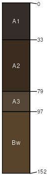
Adel loam, 2 to 15 percent slopes
Adel
(90%)
Upland Shrubland Group
Pachic Haplocryolls
Well drained
Hydric: No
PAWS: 26 cm
low hills
fan remnants
stream terraces
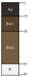
Teton
(10%)
Upland Shrubland Group
Ustic Haplocryolls
Well drained
Hydric: No
PAWS: 14 cm
low hills
SSA
Scale
Published
Export
mt027
1:24,000
1979
2025-08-30