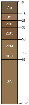
Kendallville loam, 12 to 18 percent slopes, eroded
Kendallville
(85%)
Till Ridge
Typic Hapludalfs
Well drained
Hydric: No
PAWS: 22 cm
moraines / Shoulder
steep slopes
(4%)
Hydric:
PAWS: NA
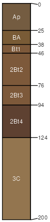
Ockley
(4%)
Dry Outwash Upland
Hydric:
PAWS: NA
terraces
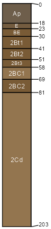
Glynwood
(4%)
Till Ridge
Hydric:
PAWS: NA
ground moraines
severely eroded areas
(3%)
Hydric:
PAWS: NA
SSA
Scale
Published
Export
oh101
1:16,000
1984
2025-09-02