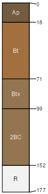
Zanesville-Westmore silt loams, 10 to 18 percent slopes, eroded
Zanesville
(46%)
Fragipan Uplands
Oxyaquic Fragiudalfs
Well drained
Hydric: No
PAWS: 19 cm
hillslopes / Backslope
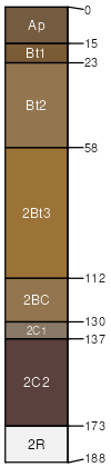
Westmore
(44%)
Loess Veneered Sandstone-Shale Uplands
Typic Hapludalfs
Well drained
Hydric: No
PAWS: 22 cm
hillslopes / Backslope
SSA
Scale
Published
Export
il199
1:12,000
2007
2025-08-31