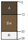
Sherless (50%)
Loamy Upland
Typic Hapludults
Well drained
Hydric: No
PAWS: 13 cm |
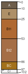
low hills / Backslope low hills / Footslope
|
|
Littlefir (35%)
Clayey Upland
Oxyaquic Hapludults
Moderately well drained
Hydric: No
PAWS: 11 cm |
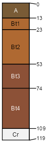
low hills / Backslope low hills / Footslope
|
|
Nashoba (8%)
Loamy Upland
Typic Dystrudepts
Well drained
Hydric: No
PAWS: 13 cm |
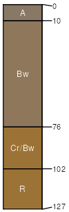
low hills / Backslope low hills / Footslope
|
|
Honobia (3%)
Clayey Upland
Typic Hapludults
Well drained
Hydric: No
PAWS: 6 cm |
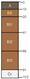
low hills / Backslope low hills / Footslope
|
|
Bismarck (3%)
Shallow Upland
Typic Dystrudepts
Somewhat excessively drained
Hydric: No
PAWS: 4 cm |

low hills / Backslope low hills / Footslope
|
|
Clebit (1%)
Shallow Upland
Lithic Dystrudepts
Well drained
Hydric: No
PAWS: 4 cm |
low hills / Backslope low hills / Footslope
|
|