Bismarck (40%)
Shallow Upland
Typic Dystrudepts
Somewhat excessively drained
Hydric: No
PAWS: 4 cm |

hills / Summit hills / Backslope
|
|
Nashoba (35%)
Loamy Upland
Typic Dystrudepts
Well drained
Hydric: No
PAWS: 7 cm |

hills / Summit hills / Backslope
|
|
Littlefir (15%)
Clayey Upland
Oxyaquic Hapludults
Moderately well drained
Hydric: No
PAWS: 11 cm |
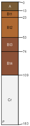
hills / Summit hills / Backslope
|
|
Clebit (10%)
Shallow Upland
Lithic Dystrudepts
Well drained
Hydric: No
PAWS: 2 cm |

hills / Summit hills / Backslope
|
|