Moosejaw-Highrye-Silas complex, 2 to 15 percent slopes
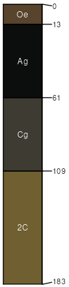
Moosejaw
(35%)
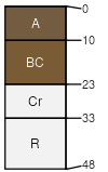
Bottomland Group
Cumulic Cryaquolls
Very poorly drained
Hydric: Yes
PAWS: 24 cm
flood plains
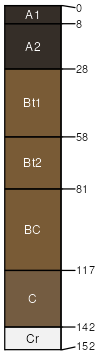
Highrye
(25%)
Upland Alpine Group
Ustic Argicryolls
Well drained
Hydric:
PAWS: 13 cm
hills
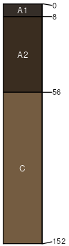
Silas
(20%)
Bottomland Group
Cumulic Haplocryolls
Moderately well drained
Hydric:
PAWS: 35 cm
hills / Toeslope
stream terraces
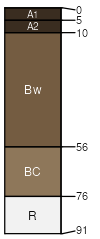
Branham
(10%)
Upland Sagebrush Shrubland Group
Ustic Haplocryolls
Well drained
Hydric:
PAWS: 8 cm
hills / Footslope
Zonite
(9%)
Shallow Sagebrush Shrubland Group
Lithic Cryorthents
Somewhat excessively drained
Hydric:
PAWS: 2 cm
escarpments / Shoulder
escarpments / Backslope
Rock outcrop
(1%)
Hydric:
PAWS: NA
SSA
Scale
Published
Export
mt635
1:24,000
2006
2025-08-31