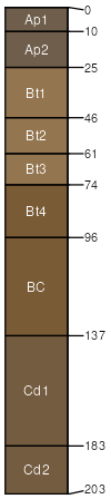
Nappanee silty clay loam, 6 to 12 percent slopes, eroded
Nappanee
(80%)
Lacustrine Forest
Wet Till Ridge
Aeric Ochraqualfs
Somewhat poorly drained
Hydric: No
PAWS: 16 cm
lake plains / Summit
lake plains / Shoulder
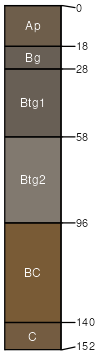
Pandora
(7%)
Till Depression
Hydric: Yes
PAWS: NA
drainageways
moderately well drained soils
(7%)
Hydric:
PAWS: NA
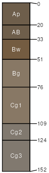
Shoals
(6%)
Wet Alluvium Forest
Hydric:
PAWS: NA
flood plains
SSA
Scale
Published
Export
oh175
1:16,000
1980
2025-09-09