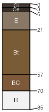
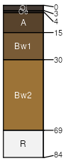
Agneston-McCall-families, Rubble land complex, 15 to 60 percent slopes

Agneston (35%)
Subirrigated (Sb) 15-19 Foothills and Mountains East Precipitation Zone
Typic Haplocryalfs
Well drained
Hydric: No
PAWS: 9 cm
mountain slopes
McCall (25%)
Subirrigated (Sb) 15-19 Foothills and Mountains East Precipitation Zone
Humic Dystrocryepts
Well drained
Hydric: No
PAWS: 3 cm
mountain slopes
Rubble land (15%)


Hydric: Unranked
PAWS: NA
Elting (5%)
Typic Dystrocryepts
Somewhat excessively drained
Hydric: No
PAWS: 3 cm
mountain slopes
Rock outcrop (5%)


Hydric: Unranked
PAWS: NA
Klutch (4%)
Typic Dystrocryepts
Well drained
Hydric: No
PAWS: 3 cm
mountain slopes
McCall (4%)
Humic Dystrocryepts
Well drained
Hydric: No
PAWS: 6 cm
mountain slopes
Hargran (4%)
Oxyaquic Dystrocryepts
Well drained
Hydric: No
PAWS: 13 cm
mountain slopes
Glaciers (2%)


Hydric: Unranked
PAWS: NA
Water (1%)


Hydric: Unranked
PAWS: NA
SSAScalePublishedExport
wy6561:24,00020082023-09-06