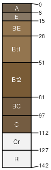
Westmoreland silt loam, 6 to 15 percent slopes
eroded areas
(%)
Hydric:
PAWS: NA
bedrock at 20 to 40 inches
(%)
Hydric:
PAWS: NA
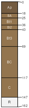
more sand in the subsoil
(%)
Hydric:
PAWS: NA
Westmoreland
(85%)
Acid Mixed Sedimentary Upland
Ultic Hapludalfs
Well drained
Hydric: No
PAWS: 17 cm
hills / Summit
Coshocton
(15%)
Hydric:
PAWS: NA
hills
SSA
Scale
Published
Export
oh075
1:16,000
1989
2025-08-29