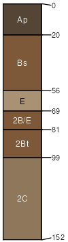
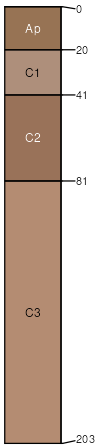
Loggerhead (45%)
Alfic Loamy Uplands
Alfic Oxyaquic Haplorthods
Moderately well drained
Hydric: No
PAWS: 32 cm |

till plains / Summit till plains / Shoulder till plains / Backslope till plains / Footslope till plains / Toeslope
|
|
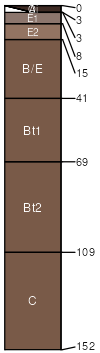
Ubly (25%)
Alfic Loamy Uplands
Alfic Haplorthods
Well drained
Hydric: No
PAWS: 36 cm |
till plains / Summit till plains / Shoulder till plains / Backslope till plains / Footslope till plains / Toeslope
|
|
Moquah (15%)
Floodplains
Typic Udifluvents
Moderately well drained
Hydric: No
PAWS: 31 cm |
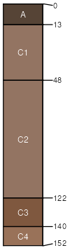
flood plains / Footslope flood plains / Toeslope
|
|
Watton (5%)
Alfic Loamy Uplands
Haplic Glossudalfs
Well drained
Hydric: No
PAWS: 25 cm |
till plains / Summit till plains / Shoulder till plains / Backslope till plains / Footslope till plains / Toeslope
|
|
Liminga (5%)
Sandy Uplands
Typic Haplorthods
Well drained
Hydric: No
PAWS: 14 cm |
outwash plains / Summit outwash plains / Shoulder outwash plains / Backslope outwash plains / Footslope outwash plains / Toeslope
|
|
Pelkie (5%)
Floodplains
Oxyaquic Udipsamments
Moderately well drained
Hydric: No
PAWS: 14 cm |
flood plains / Summit flood plains / Shoulder flood plains / Backslope flood plains / Footslope flood plains / Toeslope
|
|