Miskoaki-Schaat Creek, frequently flooded, complex, 0 to 45 percent slopes
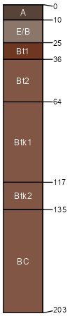
Miskoaki
(80%)
Clayey Uplands
Vertic Glossudalfs
Well drained
Hydric: No
PAWS: 21 cm
till plains / Summit
till plains / Shoulder
till plains / Backslope
till plains / Footslope
till plains / Toeslope
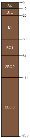
Schaat Creek
(15%)
Wet Floodplains
Aeric Endoaqualfs
Poorly drained
Hydric: Yes
PAWS: 42 cm
till plains / Footslope
flood plains / Toeslope
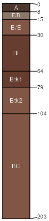
Froberg
(3%)
Loamy Uplands
Oxyaquic Vertic Hapludalfs
Moderately well drained
Hydric: No
PAWS: 29 cm
till plains / Footslope
Cuttre
(2%)
Wet Loamy or Clayey Lowlands
Aeric Glossaqualfs
Somewhat poorly drained
Hydric: No
PAWS: 19 cm
till plains / Footslope
SSA
Scale
Published
Export
mi131
1:24,000
2007
2025-09-04