Hardin Heights-Telogia complex, 5 to 45 percent slopes
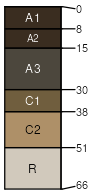
Hardin Heights
(70%)
Slopes, Basic Upland, Expansive Clay
Typic Haprendolls
Well drained
Hydric: No
PAWS: 9 cm
ridges
hillslopes
marine terraces
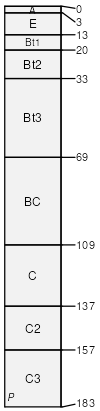
Telogia
(20%)
Slopes, Basic Upland, Expansive Clay
Vertic Hapludalfs
Somewhat poorly drained
Hydric: No
PAWS: 20 cm
ridges
marine terraces
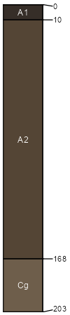
Hosford
(6%)
Upland Drainageways
Cumulic Humaquepts
Very poorly drained
Hydric: Yes
PAWS: 16 cm
seeps / Backslope
seeps / Footslope
marine terraces
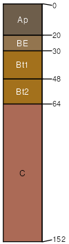
Cowarts
(4%)
Slopes, Loamy, Depth Restriction
Typic Kanhapludults
Well drained
Hydric: No
PAWS: 24 cm
valley sides
hillslopes
marine terraces
SSA
Scale
Published
Export
fl039
1:12,000
2006
2025-08-27