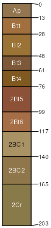
Stonehead silt loam, 2 to 6 percent slopes, eroded
Stonehead
(94%)
Deep Moderately Well Drained Siltstone-Shale Uplands
Residuum Upland Forest
Oxyaquic Hapludalfs
Moderately well drained
Hydric: No
PAWS: 24 cm
hills / Summit
hills / Shoulder
Weddel
(4%)
Hydric: No
PAWS: NA
Stonehead
(2%)
Hydric: No
PAWS: NA
SSA
Scale
Published
Export
in143
1:12,000
1995
2025-09-03