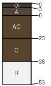
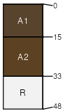
|
|
Melody (10%)
Cryic, Umbric Or Andic Slopes
Lithic Vitricryands
Excessively drained
Hydric: No
PAWS: 3 cm |

mountain slopes / Shoulder mountain slopes / Backslope
|
|
Mountrose (4%)
Cryic, Umbric Or Andic Slopes
Xeric Vitricryands
Well drained
Hydric: No
PAWS: 9 cm |

mountain slopes / Shoulder mountain slopes / Backslope
|
|
Wardcreek (3%)
Cryic, Umbric Or Andic Slopes
Xeric Vitricryands
Excessively drained
Hydric: No
PAWS: 5 cm |

mountain slopes / Shoulder mountain slopes / Backslope
|
|
Meiss (1%)
Shallow Andesite Ridge
Lithic Humicryepts
Excessively drained
Hydric: No
PAWS: 4 cm |

mountains / Summit mountains / Shoulder
|
|
|
|