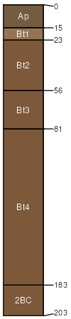
Alford silt loam, 2 to 6 percent slopes, eroded
Alford
(90%)
Dry Loess Upland
Ultic Hapludalfs
Well drained
Hydric: No
PAWS: 33 cm
ground moraines / Summit
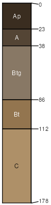
Ragsdale
(3%)
Wet Loess Upland
Hydric: Yes
PAWS: NA
SSA
Scale
Published
Export
in171
1:16,000
1987
2025-09-02