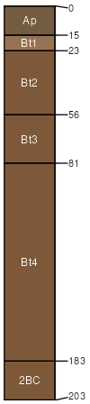
Alford silt loam, 18 to 35 percent slopes, severely eroded
Alford
(95%)
Wet Silty Eolian Forest
Ultic Hapludalfs
Well drained
Hydric: No
PAWS: 37 cm
loess hills / Backslope
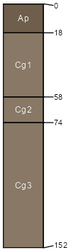
Wakeland
(5%)
Wet Floodplain Forest
Somewhat poorly drained
Hydric: No
PAWS: NA
flood plains / Toeslope
SSA
Scale
Published
Export
in027
1:20,000
1969
2025-09-04