Ustic Calcicryolls-Thornburgh-Tiban families, complex, 10 to 30 percent slopes
Ustic Calcicryolls
(40%)
Shallow Loamy (SwLy) 15-19 Foothills and Mountains East Precipitation Zone
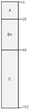
Ustic Calcicryolls
Well drained
Hydric: No
PAWS: 14 cm
mountain slopes
Tiban
(25%)
Coarse Upland (CU) 15-19 Foothills and Mountains East Precipitation Zone
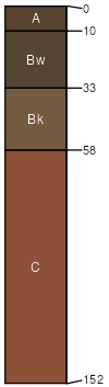
Ustic Haplocryolls
Well drained
Hydric: No
PAWS: 12 cm
debris flows
Thornburgh
(25%)
Upland Warm Woodland Group
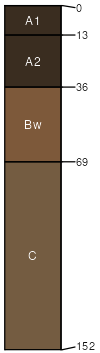
Ustic Haplocryolls
Well drained
Hydric: No
PAWS: 14 cm
mountain slopes
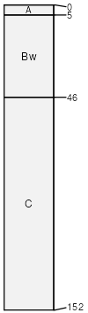
Haplocryolls
(10%)
Well drained
Hydric: No
PAWS: 9 cm
landslides
SSA
Scale
Published
Export
wy656
1:24,000
2008
2025-09-04