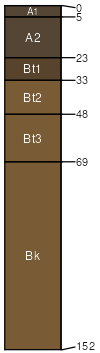
Venapass-Silas loams, 0 to 6 percent slopes
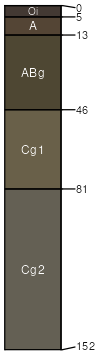
Venapass
(55%)
Wetland High Plains Southeast (WL)
Typic Cryaquolls
Poorly drained
Hydric: Yes
PAWS: 18 cm
flood plains
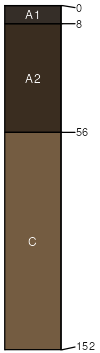
Silas
(30%)
Loamy Overflow High Plains Southeast (LyO)
Cumulic Haplocryolls
Moderately well drained
Hydric: No
PAWS: 29 cm
terraces
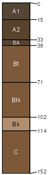
Absher
(4%)
Saline Lowland High Plains Southeast (SL)
Leptic Torrertic Natrustalfs
Moderately well drained
Hydric: No
PAWS: 16 cm
alluvial flats
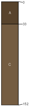
Gelkie
(4%)
Loamy Overflow High Plains Southeast (LyO)
Ustic Argicryolls
Well drained
Hydric: No
PAWS: 25 cm
terraces
Uhl
(4%)
Loamy Overflow High Plains Southeast (LyO)
Ustic Haplocryolls
Well drained
Hydric: No
PAWS: 26 cm
alluvial fans
Hoodle
(3%)
Gravelly High Plains Southeast (Gr)
Ustic Argicryolls
Well drained
Hydric: No
PAWS: 12 cm
mountain slopes
SSA
Scale
Published
Export
wy647
1:24,000
2025-09-04