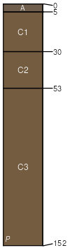
Glenton-Riverwash-Tipperary complex, 0 to 3 percent slopes
Glenton
(45%)
Lowland (LL) 5-9 Wind River Basin Precipitation Zone
Typic Torrifluvents
Well drained
Hydric: No
PAWS: 20 cm
alluvial flats
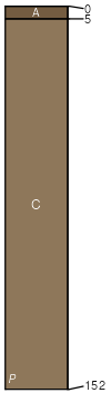
Riverwash
(30%)
Hydric: No
PAWS: NA
alluvial flats
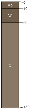
Tipperary
(15%)
Lowland (LL) 5-9 Wind River Basin Precipitation Zone
Typic Torripsamments
Somewhat excessively drained
Hydric: No
PAWS: 12 cm
alluvial flats
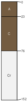
Youngston
(5%)
Clayey (Cy) 5-9 Wind River Basin Precipitation Zone
Typic Torrifluvents
Well drained
Hydric: No
PAWS: 30 cm
drainageways
Teapo
(5%)
Loamy (Ly) 5-9 Wind River Basin Precipitation Zone
Typic Torriorthents
Well drained
Hydric: No
PAWS: 11 cm
hills / Toeslope
SSA
Scale
Published
Export
wy647
1:24,000
2025-09-04