Thermopolis-Sinkson association, 3 to 30 percent slopes
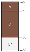
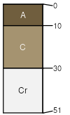
Thermopolis
(60%)
Shallow Loamy (SwLy) 10-14 East Precipitation Zone
Ustic Torriorthents
Well drained
Hydric: No
PAWS: 4 cm
ridges
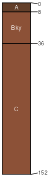
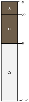
Sinkson
(20%)
Loamy (Ly) 10-14 East Precipitation Zone
Ustic Torriorthents
Well drained
Hydric: No
PAWS: 26 cm
fan aprons
Rock outcrop
(4%)
Hydric: No
PAWS: NA
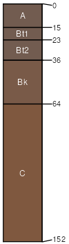
Almy
(4%)
Loamy (Ly) 10-14 East Precipitation Zone
Ustic Haplargids
Well drained
Hydric: No
PAWS: 26 cm
basin floors
Diamondville
(4%)
Loamy High Plains Southeast (Ly)
Ustic Haplargids
Well drained
Hydric: No
PAWS: 10 cm
hillslopes
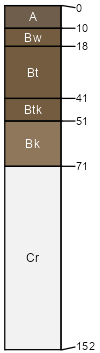
Blackhall
(4%)
Shallow Sandy High Plains Southeast (SwSy)
Ustic Torriorthents
Well drained
Hydric: No
PAWS: 6 cm
ridges
hills
Carmody
(4%)
Sandy High Plains Southeast (Sy)
Ustic Torriorthents
Well drained
Hydric: No
PAWS: 9 cm
plateaus
hillslopes
SSA
Scale
Published
Export
wy647
1:24,000
2025-09-04