Worland-Oceanet-Persayo complex, 1 to 15 percent slopes
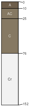
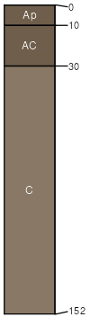
Worland
(40%)
Sandy (Sy) 5-9 Wind River Basin Precipitation Zone
Typic Torriorthents
Well drained
Hydric: No
PAWS: 10 cm
hills / Backslope
hills / Footslope
hills / Summit
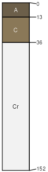
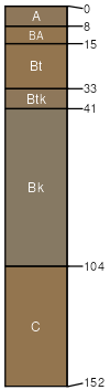
Oceanet
(20%)
Shallow Sandy (SwSy) 5-9 Wind River Basin Precipitation Zone
Typic Torriorthents
Well drained
Hydric: No
PAWS: 6 cm
hills / Shoulder
hills / Summit
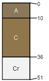
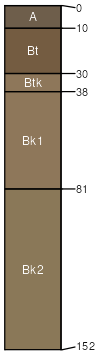
Persayo
(15%)
Shallow Clayey (SwCy) 5-9 Wind River Basin Precipitation Zone
Typic Torriorthents
Well drained
Hydric: No
PAWS: 8 cm
hillslopes / Shoulder
hillslopes / Summit
Rock outcrop
(5%)
Hydric: No
PAWS: NA
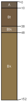
Griffy
(5%)
Sandy (Sy) 5-9 Wind River Basin Precipitation Zone
Typic Haplargids
Well drained
Hydric: No
PAWS: 18 cm
terraces
alluvial fans
Youngston
(5%)
Clayey (Cy) 5-9 Wind River Basin Precipitation Zone
Typic Torrifluvents
Well drained
Hydric: No
PAWS: 30 cm
terraces
alluvial fans
drainageways
Frisite
(5%)
Loamy (Ly) 5-9 Wind River Basin Precipitation Zone
Typic Haplargids
Well drained
Hydric: No
PAWS: 28 cm
terraces
Wallson
(5%)
Sandy (Sy) 5-9 Wind River Basin Precipitation Zone
Typic Haplargids
Well drained
Hydric: No
PAWS: 18 cm
alluvial fans
hills / Toeslope
valley floors
SSA
Scale
Published
Export
wy647
1:24,000
2025-09-04