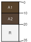
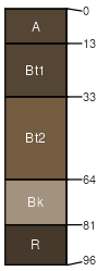
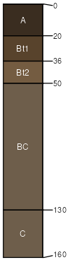
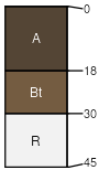
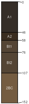
Vershal, very cobbly - Sawicki, extremely stony - Absarook complex, 8 to 45 percent slopes

Vershal (30%)
Shallow Sagebrush Shrubland
Lithic Haplustolls
Well drained
Hydric: No
PAWS: 1 cm
escarpments / Shoulder
escarpments / Backslope
Sawicki (20%)
Upland Shrubland Group
Typic Argiustolls
Well drained
Hydric: No
PAWS: 10 cm
escarpments / Backslope
Absarook (20%)
Loamy Steep (LoStp) LRU 01 Subset B
Typic Argiustolls
Well drained
Hydric: No
PAWS: 11 cm
hillslopes / Backslope
hillslopes / Footslope
Martinsdale (12%)
Loamy Steep (LoStp) LRU 01 Subset B
Typic Argiustolls
Well drained
Hydric: No
PAWS: 25 cm
escarpments / Backslope
escarpments / Footslope
swales / Footslope
Tolbert (8%)
Shallow Shrubland Group
Lithic Argiustolls
Well drained
Hydric: No
PAWS: 3 cm
hillslopes / Backslope
escarpments / Backslope
Rock outcrop (5%)


Hydric:
PAWS: NA
Laceycreek (5%)
Loamy Steep (LoStp) LRU 01 Subset B
Pachic Argiustolls
Well drained
Hydric: No
PAWS: NA
escarpments / Backslope
escarpments / Footslope
hillslopes / Backslope
hillslopes / Footslope
SSAScalePublishedExport
mt6691:24,0002023-08-29