Nirling-Clunton complex, 0 to 10 percent slopes, occasionally flooded
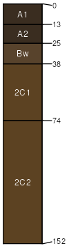
Nirling
(60%)
Upland Sagebrush Shrubland Group
Oxyaquic Haplustolls
Somewhat poorly drained
Hydric: No
PAWS: 8 cm
drainageways
flood-plain steps
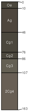
Clunton
(20%)
Subirrigated Grassland
Fluvaquentic Endoaquolls
Very poorly drained
Hydric: Yes
PAWS: 21 cm
flood-plain steps
drainageways
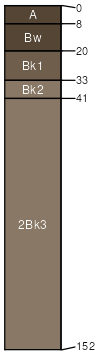
Cozdome
(10%)
Shallow to Gravel (SwGr) 10-14 PZ Frigid
Aridic Haplustolls
Well drained
Hydric: No
PAWS: 7 cm
drainageways
flood-plain steps
Vendome
(10%)
Shallow to Gravel (SwGr) 10-14 PZ Frigid
Aridic Haplustolls
Well drained
Hydric: No
PAWS: 10 cm
drainageways
flood-plain steps
SSA
Scale
Published
Export
mt669
1:24,000
2025-09-03