Mishakal loam, 35 to 60 percent slopes
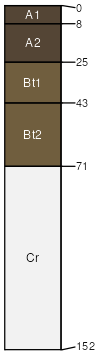
Mishakal
(85%)
Upland Warm Woodland
Typic Argiustolls
Well drained
Hydric: No
PAWS: 10 cm
mountains
hills
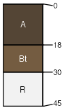
Tolbert
(6%)
Shallow Droughty (SwDr) 15-19 PZ Frigid North
Lithic Argiustolls
Well drained
Hydric: Unranked
PAWS: 4 cm
mountain slopes
mountains
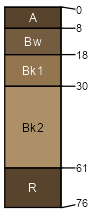
Wilspring
(5%)
Typic Haplustepts
Well drained
Hydric: Unranked
PAWS: 7 cm
mountains
hills / Shoulder
hills / Backslope
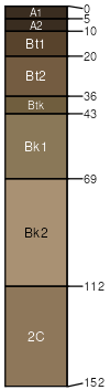
Danvers
(3%)
Upland Grassland Group
Vertic Argiustolls
Well drained
Hydric: Unranked
PAWS: 22 cm
stream terraces
alluvial fans
Rock outcrop
(1%)
Hydric: Unranked
PAWS: NA
SSA
Scale
Published
Export
mt616
1:24,000
2003
2025-08-30