Bributte-Persayo-Rock outcrop complex, 3 to 60 percent slopes -- Draft
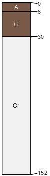
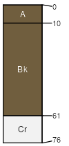
Bributte
(35%)
Saline Upland (SU) 5-9 Big Horn Basin Precipitation Zone
Typic Torriorthents
Well drained
Hydric: No
PAWS: 7 cm
basin-floor remnants / Shoulder
basin-floor remnants / Summit
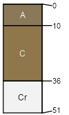
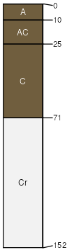
Persayo
(30%)
Shale (Sh) 5-9 Big Horn Basin Precipitation Zone
Typic Torriorthents
Well drained
Hydric: No
PAWS: 6 cm
hills / Shoulder
hills / Summit
Rock outcrop
(15%)
Hydric: No
PAWS: NA
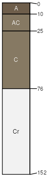
Worland
(5%)
Sandy (Sy) 5-9 Big Horn Basin Precipitation Zone,
Typic Torriorthents
Well drained
Hydric: No
PAWS: 9 cm
hills / Backslope
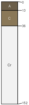
Oceanet
(5%)
Shallow Sandy (SwSy) 5-9 Big Horn Basin Precipitation Zone
Typic Torriorthents
Well drained
Hydric: No
PAWS: 5 cm
hills / Shoulder
hills / Summit
Deaver
(5%)
Saline Upland (SU) 5-9 Big Horn Basin Precipitation Zone
Typic Torriorthents
Well drained
Hydric: No
PAWS: 12 cm
hills / Backslope
Greybull
(5%)
Saline Upland (SU) 5-9 Big Horn Basin Precipitation Zone
Typic Torriorthents
Well drained
Hydric: No
PAWS: 13 cm
hills / Shoulder
hills / Summit
SSA
Scale
Published
Export
wy629
1:24,000
2025-09-04