Shingle-Thedalund-Midway complex, 0 to 35 percent slopes -- Draft
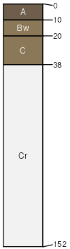
Shingle
(35%)
Shallow Loamy (SwLy) 5-9 Big Horn Basin Precipitation Zone
Ustic Torriorthents
Well drained
Hydric: No
PAWS: 7 cm
hills / Shoulder
hills / Summit
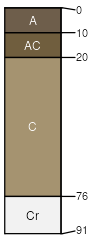
Thedalund
(30%)
Loamy (Ly) 5-9 Big Horn Basin Precipitation Zone
Ustic Torriorthents
Well drained
Hydric: No
PAWS: 11 cm
hills / Backslope
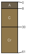
Midway
(20%)
Shallow Clayey (SwCy) 5-9 Big Horn Basin Precipitation Zone
Ustic Torriorthents
Well drained
Hydric: No
PAWS: 7 cm
hills / Shoulder
hills / Summit
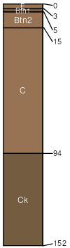
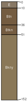
Winnett
(5%)
Ustic Natrargids
Hydric: No
PAWS: NA
Arvada
(5%)
Ustertic Natrargids
Hydric: No
PAWS: NA
Rock outcrop
(5%)
Hydric:
PAWS: NA
SSA
Scale
Published
Export
wy629
1:24,000
2025-09-04