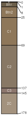
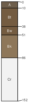
Mudray like very channery-Muff-Bributte complex, 0 to 10 percent slopes -- Draft

Mudray like (40%)
Saline Upland (SU) 5-9 Big Horn Basin Precipitation Zone
Typic Natrargids
Well drained
Hydric: No
PAWS: 9 cm
hills / Shoulder
Muff (25%)
Saline Upland (SU) 5-9 Big Horn Basin Precipitation Zone
Typic Natrargids
Well drained
Hydric: No
PAWS: 11 cm
hills / Backslope
Bributte (15%)
Shale (Sh) 5-9 Big Horn Basin Precipitation Zone
Typic Torriorthents
Well drained
Hydric: No
PAWS: 7 cm
hills / Summit
hills / Shoulder
Uffens (5%)
Saline Upland (SU) 5-9 Big Horn Basin Precipitation Zone
Typic Natrargids
Well drained
Hydric: No
PAWS: 22 cm
alluvial fans
Mudray (5%)
Typic Natrargids
Well drained
Hydric: No
PAWS: NA
Chipeta (3%)
Saline Upland (SU) 5-9 Big Horn Basin Precipitation Zone
Typic Torriorthents
Well drained
Hydric: No
PAWS: 2 cm
basin-floor remnants / Summit
basin-floor remnants / Shoulder
Persayo (3%)
Saline Upland (SU) 5-9 Big Horn Basin Precipitation Zone
Typic Torriorthents
Well drained
Hydric: No
PAWS: 6 cm
hills / Shoulder
hills / Summit
Deaver (2%)
Typic Torriorthents
Well drained
Hydric: No
PAWS: NA
Enos (2%)
Sandy (Sy) 5-9 Big Horn Basin Precipitation Zone,
Typic Haplargids
Well drained
Hydric: No
PAWS: 11 cm
low hills / Backslope
low hills / Footslope
SSAScalePublishedExport
wy6031:24,0002023-09-05