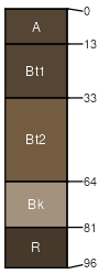
Absarook (50%)
Upland Grassland Group
Typic Argiustolls
Well drained
Hydric: No
PAWS: 13 cm |
ridges / Shoulder ridges / Backslope ridges / Footslope hillsides / Shoulder hillsides / Backslope
|
|
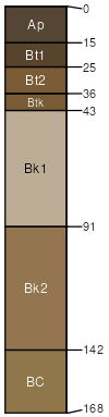
Martinsdale (35%)
Upland Grassland Group
Typic Argiustolls
Well drained
Hydric: No
PAWS: 21 cm |
terraces hillsides alluvial fans
|
|
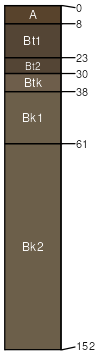
Martinsdale (5%)
Upland Grassland Group
Typic Argiustolls
Well drained
Hydric: No
PAWS: 21 cm |
terraces hillsides alluvial fans
|
|
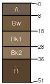
Absarook (5%)
Upland Shrubland Group
Typic Argiustolls
Well drained
Hydric: No
PAWS: 13 cm |
ridges / Shoulder ridges / Backslope ridges / Footslope hillsides / Shoulder hillsides / Backslope
|
|
Devilfence (3%)
Shallow Shrubland Group
Lithic Haplustepts
Somewhat excessively drained
Hydric: No
PAWS: 3 cm |
hillsides escarpments ridges
|
|
Shawmut (2%)
Upland Grassland Group
Typic Argiustolls
Well drained
Hydric: No
PAWS: 12 cm |
hillsides escarpments alluvial fans
|
|