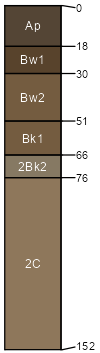
Raghorn sandy loam, 4 to 8 percent slopes
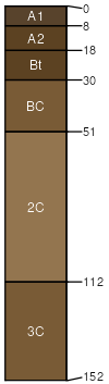
Raghorn
(85%)
Sandy (Sy) 10-14 PZ Frigid
Aridic Haplustalfs
Well drained
Hydric: No
PAWS: 16 cm
knolls
hillsides
alluvial fans
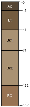
Varney
(5%)
Loamy (Lo) 10-14 PZ Frigid
Calcidic Argiustolls
Well drained
Hydric: No
PAWS: 18 cm
alluvial fans
knolls
hillsides
terraces
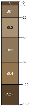
Bronec
(4%)
Droughty (Dr) 10-14 PZ Frigid
Aridic Calciustepts
Well drained
Hydric: No
PAWS: 15 cm
alluvial fans
hillsides
escarpments
valley floors
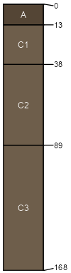
Yetull
(3%)
Sandy (Sy) 10-14 PZ Frigid
Aridic Ustipsamments
Somewhat excessively drained
Hydric: No
PAWS: 9 cm
alluvial fans
hills
Cozberg
(3%)
Sandy (Sy) 10-14 PZ Frigid
Aridic Haplustolls
Well drained
Hydric: No
PAWS: 15 cm
valley floors
terraces
alluvial fans
SSA
Scale
Published
Export
mt627
1:24,000
1998
2025-08-31