Rencot-Lahood-Rock outcrop complex, 8 to 25 percent slopes
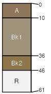
Rencot
(50%)
Shallow Sagebrush Shrubland
Lithic Calciustepts
Well drained
Hydric: No
PAWS: 4 cm
strath terraces
hillsides
escarpments
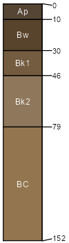
Lahood
(25%)
Droughty (Dr) 10-14 PZ Frigid
Aridic Haplustolls
Well drained
Hydric: No
PAWS: 10 cm
strath terraces
hillsides
escarpments
Rock outcrop
(15%)
Hydric: Unranked
PAWS: NA
Lahood
(2%)
Droughty Steep (DrStp) 10-14 PZ Frigid
Aridic Haplustolls
Well drained
Hydric: No
PAWS: 11 cm
strath terraces
hillsides
escarpments
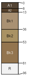
Anamac
(2%)
Loamy (Lo) 10-14 PZ Frigid
Aridic Haplustolls
Well drained
Hydric: No
PAWS: 25 cm
terraces
hillsides
alluvial fans
Rencot
(2%)
Shallow Shrubland Group
Lithic Calciustepts
Well drained
Hydric: No
PAWS: 4 cm
strath terraces
hillsides
escarpments
Sixbeacon
(2%)
Loamy (Lo) 10-14 PZ Frigid
Aridic Haplustolls
Well drained
Hydric: No
PAWS: 8 cm
valley floors
terraces
alluvial fans
Haxby
(2%)
Loamy Steep (LoStp) 10-14 PZ Frigid
Haplocalcidic Haplustepts
Well drained
Hydric: No
PAWS: 12 cm
strath terraces
ridges
hillsides
SSA
Scale
Published
Export
mt627
1:24,000
1998
2025-08-31