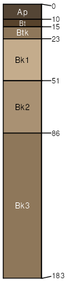
Sappington-Geohrock complex, 8 to 15 percent slopes
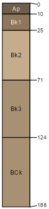
Sappington
(40%)
Clayey (Cy) 10-14 PZ Frigid
Calcidic Argiustolls
Well drained
Hydric: No
PAWS: 20 cm
knolls
plains
hillsides / Footslope
hillsides / Toeslope
alluvial fans
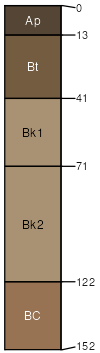
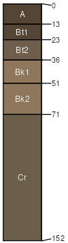
Geohrock
(35%)
Droughty (Dr) 10-14 PZ Frigid
Aridic Haplustalfs
Well drained
Hydric: No
PAWS: 9 cm
valley floors
terraces
alluvial fans
Geohrock
(5%)
Droughty (Dr) 10-14 PZ Frigid
Aridic Haplustalfs
Well drained
Hydric: No
PAWS: 9 cm
valley floors
terraces
alluvial fans
Sappington
(5%)
Clayey (Cy) 10-14 PZ Frigid
Calcidic Argiustolls
Well drained
Hydric: No
PAWS: 20 cm
knolls
plains
hillsides / Footslope
hillsides / Toeslope
alluvial fans
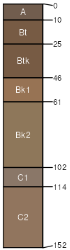
Varney
(5%)
Clayey (Cy) 10-14 PZ Frigid
Calcidic Argiustolls
Well drained
Hydric: No
PAWS: 18 cm
alluvial fans
hillsides
knolls
terraces
Bronec
(4%)
Droughty Steep (DrStp) 10-14 PZ Frigid
Aridic Calciustepts
Well drained
Hydric: No
PAWS: 15 cm
alluvial fans
hillsides
escarpments
valley floors
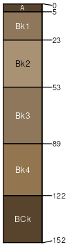
Amesha
(4%)
Loamy Steep (LoStp) 10-14 PZ Frigid
Aridic Calciustepts
Well drained
Hydric: No
PAWS: 21 cm
knolls
plains
hillsides / Footslope
hillsides / Toeslope
alluvial fans
Udecide
(2%)
Loamy (Lo) 10-14 PZ Frigid
Aridic Argiustolls
Well drained
Hydric: No
PAWS: 11 cm
interfluves
hillsides
knolls
SSA
Scale
Published
Export
mt627
1:24,000
1998
2025-08-31