Cardwell-Riverrun complex, 0 to 2 percent slopes, saline
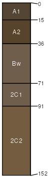
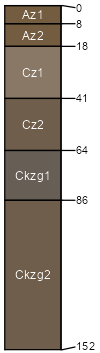
Cardwell
(45%)
Subirrigated Saline-Sodic Grassland
Oxyaquic Haplustolls
Somewhat poorly drained
Hydric: No
PAWS: 11 cm
flood-plain steps
flood plains
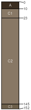
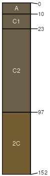
Riverrun
(40%)
Shallow to Gravel (SwGr) 10-14 PZ Frigid
Oxyaquic Ustifluvents
Moderately well drained
Hydric: No
PAWS: 5 cm
drainageways
flood-plain steps
flood plains
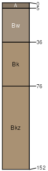
Trudau
(5%)
Saline Upland (SU) 10-14 PZ Frigid
Aridic Haplustepts
Well drained
Hydric: No
PAWS: 15 cm
flood-plain steps
knolls
alluvial fans
terraces
stream terraces
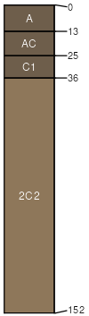
Wetsand
(5%)
Subirrigated Saline-Sodic Shrubland Group
Aeric Fluvaquents
Poorly drained
Hydric: Yes
PAWS: 8 cm
flood plains
flood-plain steps
drainageways
Ledger
(3%)
Subirrigated Saline-Sodic Shrubland Group
Oxyaquic Ustifluvents
Somewhat poorly drained
Hydric: No
PAWS: 17 cm
flood-plain steps
flood plains
drainageways
Handke
(2%)
Overflow (Ov) 10-14 PZ Frigid
Oxyaquic Ustifluvents
Somewhat poorly drained
Hydric: No
PAWS: 14 cm
flood-plain steps
flood plains
drainageways
SSA
Scale
Published
Export
mt627
1:24,000
1998
2025-08-31