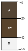
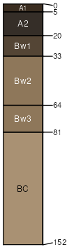
Surdal (40%)
Upland Shrubland Group
Ustic Haplocryolls
Well drained
Hydric: No
PAWS: 9 cm |
escarpments mountain slopes ridges
|
|
|
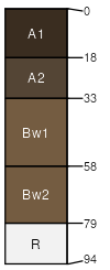
Sebud (8%)
Upland Grassland Group
Ustic Haplocryolls
Well drained
Hydric: No
PAWS: 15 cm |
alluvial fans mountain slopes
|
|
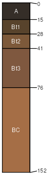
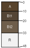
Tibkey (7%)
Subirrigated Shrubland Group
Fluvaquentic Haplocryolls
Somewhat poorly drained
Hydric: No
PAWS: 16 cm |
alluvial fans mountain valleys mountain slopes
|
|
Nieman (4%)
Shallow Shrubland Group
Lithic Argicryolls
Well drained
Hydric: No
PAWS: 3 cm |
ridges escarpments mountain slopes
|
|
Rock outcrop (3%)
Hydric: No
PAWS: NA |

|
|
Rubble land (3%)
Hydric: No
PAWS: NA |
|
|
|
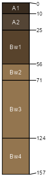
Monaberg (3%)
Upland Shrubland Group
Ustic Argicryolls
Well drained
Hydric: No
PAWS: 23 cm |
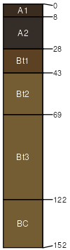
mountain slopes alluvial fans
|
|
|