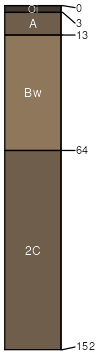
Silverking silt loam, 0 to 3 percent slopes
Silverking
(85%)
Bottomland Group
Aquic Ustochrepts
Somewhat poorly drained
Hydric: No
PAWS: 13 cm
flood plains
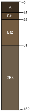
Silvercity
(7%)
Upland Shrubland Group
Typic Argiustolls
Well drained
Hydric: No
PAWS: 10 cm
flood plains
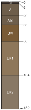
Slategoat
(4%)
Typic Haplustepts
Moderately well drained
Hydric: No
PAWS: 25 cm
flood plains
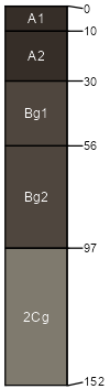
Turrah
(4%)
Subirrigated Shrubland Group
Cumulic Endoaquolls
Poorly drained
Hydric: Yes
PAWS: 20 cm
flood plains
SSA
Scale
Published
Export
mt630
1:24,000
1991
2025-08-30