Baxendale-Castner complex, 4 to 15 percent slopes
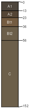
Baxendale
(70%)
Upland Grassland Group
Typic Argiustolls
Well drained
Hydric: No
PAWS: 12 cm
hills
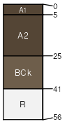
Castner
(20%)
Shallow Grassland Group
Lithic Haplustolls
Well drained
Hydric: No
PAWS: 3 cm
hills
Slopes more than 15 percent
(5%)
Hydric: No
PAWS: NA
Rock outcrop
(5%)
Hydric: No
PAWS: NA
SSA
Scale
Published
Export
mt630
1:24,000
1991
2025-08-30