Crittenden-Kalsted, bedrock substratum, sandy loams, 2 to 8 percent slopes
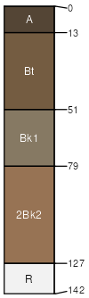
Crittenden
(50%)
Upland Grassland Group
Aridic Argiustolls
Well drained
Hydric: No
PAWS: 13 cm
low hills
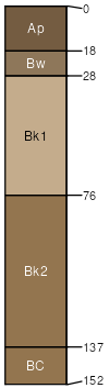
Kalsted
(40%)
Sandy (Sy) 10-14 PZ Frigid
Aridic Calciustepts
Well drained
Hydric: No
PAWS: 15 cm
low hills
Rock outcrop
(10%)
Hydric: No
PAWS: NA
SSA
Scale
Published
Export
mt630
1:24,000
1991
2025-08-30