Bangtail-Copenhaver complex, 35 to 60 percent slopes
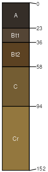
Bangtail
(70%)
Upland Grassland Group
Ustic Argicryolls
Well drained
Hydric: No
PAWS: 17 cm
hills
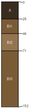
Copenhaver
(20%)
Shallow Cool Woodland Group
Lithic Argicryolls
Well drained
Hydric: No
PAWS: 4 cm
hills
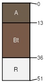
Redchief
(6%)
Upland Shrubland Group
Ustic Argicryolls
Well drained
Hydric: No
PAWS: 12 cm
hills
Rock outcrop
(4%)
Hydric: Unranked
PAWS: NA
SSA
Scale
Published
Export
mt636
1:24,000
1983
2025-08-31