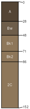
Maxville-Bearmouth complex, rarely flooded, 0 to 4 percent slopes
Maxville
(50%)
Upland Cool Woodland Group
Ustic Haplocryolls
Well drained
Hydric: No
PAWS: 16 cm
flood plains
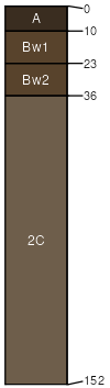
Bearmouth
(40%)
Shallow to Gravel (SwGr) 10-14 PZ Frigid
Ustic Haplocryolls
Well drained
Hydric: No
PAWS: 7 cm
stream terraces
alluvial fans
Bearmouth
(8%)
Upland Sagebrush Shrubland Group
Ustic Haplocryolls
Well drained
Hydric: No
PAWS: 9 cm
stream terraces
alluvial fans
Poorly drained soils
(2%)
Subirrigated Grassland Group
Cumulic Cryaquolls
Poorly drained
Hydric: Yes
PAWS: 25 cm
flood plains
SSA
Scale
Published
Export
mt636
1:24,000
1983
2025-08-31