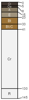
Wilkes sandy loam, 7 to 15 percent slopes, moderately eroded
Wilkes
(75%)
Basic Upland Forest, Depth Restriction, Dry
Typic Hapludalfs
Well drained
Hydric: No
PAWS: 7 cm
interfluves / Backslope
SSA
Scale
Published
Export
sc071
1:24,000
2005
2025-08-29