Roy-Tolbert complex, 15 to 35 percent slopes
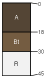
Roy
(65%)
Upland Grassland Group
Typic Argiustolls
Well drained
Hydric: No
PAWS: 12 cm
mountains
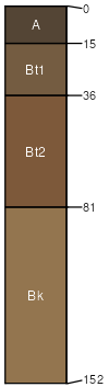
Tolbert
(20%)
Shallow Grassland Group
Lithic Argiustolls
Well drained
Hydric: No
PAWS: 4 cm
mountains
Rock outcrop
(8%)
Hydric: No
PAWS: NA
mountains
Rubble land
(7%)
Hydric: No
PAWS: NA
mountains
SSA
Scale
Published
Export
mt644
1:24,000
1995
2025-09-03