Annalake-Stutts-Arnheim, frequently flooded, complex, drainageway, 0 to 35 percent slopes
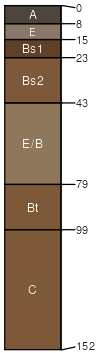
Annalake
(40%)
Alfic Loamy Uplands
Alfic Oxyaquic Haplorthods
Moderately well drained
Hydric: No
PAWS: 31 cm
river valleys
fluvial terraces
till plains
till plains
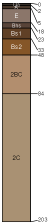
Stutts
(35%)
Sandy Uplands
Typic Haplorthods
Somewhat excessively drained
Hydric: No
PAWS: 15 cm
outwash plains / Summit
outwash plains / Shoulder
outwash plains / Backslope
outwash plains / Footslope
outwash plains / Toeslope
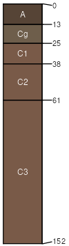
Arnheim
(25%)
Floodplains
Typic Fluvaquents
Poorly drained
Hydric: Yes
PAWS: 38 cm
flood plains
fluvial terraces
SSA
Scale
Published
Export
mi053
1:24,000
2007
2025-09-03