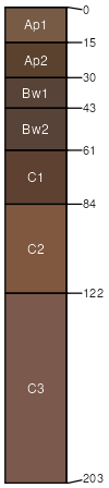
Crisfield sandy loam, rarely flooded
Crisfield
(99%)
Sandy Bottomland
Udic Haplustepts
Moderately well drained
Hydric: No
PAWS: 13 cm
flood plains
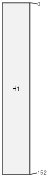
Aquolls
(1%)
Poorly drained
Hydric: Yes
PAWS: NA
depressions
drainageways
hillslopes
SSA
Scale
Published
Export
ks191
1:24,000
1974
2025-08-27