Cushman-Forkwood complex, 3 to 15 percent slopes
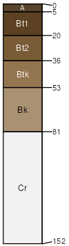
Cushman
(45%)
Loamy High Plains Southeast (Ly)
Ustic Haplargids
Well drained
Hydric: No
PAWS: 12 cm
hills / Shoulder
hills / Backslope
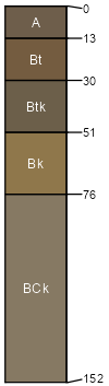
Forkwood
(40%)
Loamy High Plains Southeast (Ly)
Ustic Haplargids
Well drained
Hydric: No
PAWS: 35 cm
hills / Footslope
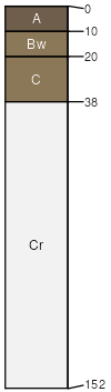
Shingle
(5%)
Shallow Loamy High Plains Southeast (SwLy)
Ustic Torriorthents
Well drained
Hydric: No
PAWS: 6 cm
hills / Summit
hills / Shoulder
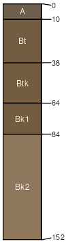
Ulm
(5%)
Clayey High Plains Southeast (Cy)
Ustic Haplargids
Well drained
Hydric: No
PAWS: 36 cm
hills / Footslope
Keyner
(5%)
Loamy High Plains Southeast (Ly)
Haplic Ustic Natrargids
Well drained
Hydric: No
PAWS: 23 cm
hills / Footslope
SSA
Scale
Published
Export
wy709
1:24,000
1983
2025-09-04