Rubick-Surdal complex, 30 to 70 percent slopes, very stony
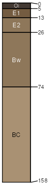
Rubick
(60%)
Upland Cool Woodland Group
Ustic Eutrocryepts
Somewhat excessively drained
Hydric: No
PAWS: 10 cm
mountains / Backslope
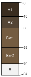
Surdal
(20%)
Upland Shrubland Group
Ustic Haplocryolls
Well drained
Hydric: No
PAWS: 5 cm
mountains / Backslope
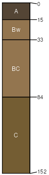
Mawspring
(6%)
Upland Sagebrush Shrubland Group
Ustic Haplocryepts
Well drained
Hydric: No
PAWS: 9 cm
mountains / Backslope
mountains / Footslope
Rock outcrop
(6%)
Hydric:
PAWS: NA
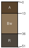
Sigbird
(4%)
Shallow Sagebrush Shrubland Group
Lithic Eutrocryepts
Somewhat excessively drained
Hydric: No
PAWS: 3 cm
mountains / Summit
mountains / Shoulder
Rubble land
(4%)
Hydric:
PAWS: NA
SSA
Scale
Published
Export
mt670
1:24,000
2007
2025-09-03