Bratton silt loam, 12 to 18 percent slopes, moderately eroded
severely eroded areas
(%)
Hydric:
PAWS: NA
Gasconade
(%)
Hydric:
PAWS: NA
hills
Opequon
(%)
Hydric:
PAWS: NA
hills
bedrock outcrop
(%)
Hydric: Unranked
PAWS: NA
slightly eroded areas
(%)
Hydric:
PAWS: NA
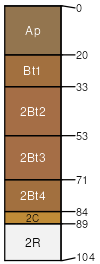
Bratton
(100%)
Ordovician Limestone Upland
Typic Hapludalfs
Well drained
Hydric: No
PAWS: 12 cm
hills
SSA
Scale
Published
Export
oh071
1:16,000
1973
2025-08-29