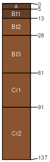
Barkerville-Gaddes association, steep
Barkerville
(60%)
Shallow Hills 16-20 p.z.
Udorthentic Haplustolls
Well drained
Hydric: No
PAWS: 4 cm
mountains / Summit
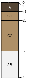
Gaddes
(25%)
Shallow Hills 16-20 p.z.
Ustollic Haplargids
Well drained
Hydric: No
PAWS: 8 cm
mountains / Summit
Rock outcrop
(15%)
Hydric: No
PAWS: NA
SSA
Scale
Published
Export
az667
1:20,000
1971
2025-08-27