Lybrand silt loam, 12 to 18 percent slopes, eroded
moderately well drained soils
(%)
Hydric:
PAWS: NA
more clay in the surface layer
(%)
Hydric:
PAWS: NA
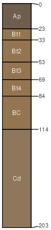
Lybrand
(90%)
Till Ridge
Typic Hapludalfs
Well drained
Hydric: No
PAWS: 20 cm
end moraines / Backslope
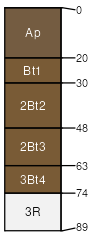
Milton
(10%)
Dry Bedrock Forest
Hydric:
PAWS: NA
till plains
SSA
Scale
Published
Export
oh159
1:16,000
1970
2025-09-08