Chatfield-Canton complex, 25 to 50 percent slopes, rocky
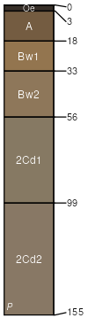
Chatfield
(60%)
Well Drained Till Uplands
Typic Dystrudepts
Well drained
Hydric: No
PAWS: 11 cm
ridges / Summit
ridges / Shoulder
ridges / Backslope
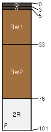
Canton
(30%)
Well Drained Till Uplands
Typic Dystrudepts
Well drained
Hydric: No
PAWS: 19 cm
hills / Backslope
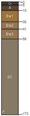
Montauk
(5%)
Oxyaquic Dystrudepts
Well drained
Hydric: No
PAWS: 23 cm
hills / Backslope
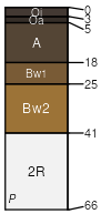
Hollis
(4%)
Lithic Dystrudepts
Somewhat excessively drained
Hydric: No
PAWS: 7 cm
ridges / Summit
ridges / Shoulder
ridges / Backslope
Rock outcrop
(1%)
Hydric: No
PAWS: 0 cm
ridges
SSA
Scale
Published
Export
ma011
1:12,000
2012
2025-09-05