El Cacique-La Taina complex, 5 to 20 percent slopes
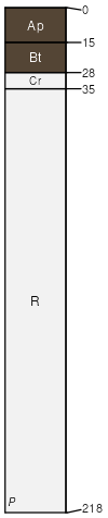
El Cacique
(60%)
Subhumid serpentine mountain ridge and valley slope woodland, shallow and potentially droughty soils
Lithic Argiudolls
Well drained
Hydric: No
PAWS: 2 cm
mountain slopes / Summit
mountain slopes / Shoulder
mountain slopes / Backslope
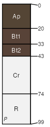
La Taina
(30%)
Subhumid serpentine mountain ridge and valley slope woodland, shallow and potentially droughty soils
Typic Argiudolls
Well drained
Hydric: No
PAWS: 2 cm
mountain slopes / Summit
mountain slopes / Shoulder
mountain slopes / Backslope
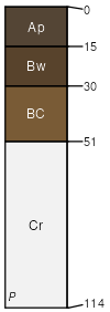
Maresua
(5%)
Subhumid serpentine mountain ridge and valley slope woodland, shallow and potentially droughty soils
Typic Argiudolls
Well drained
Hydric: No
PAWS: 5 cm
mountain slopes / Summit
mountain slopes / Shoulder
mountain slopes / Backslope
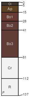
Rosario
(4%)
Subhumid serpentine mountain ridge and valley slope woodland, shallow and potentially droughty soils
Lithic Hapludox
Well drained
Hydric: No
PAWS: 10 cm
mountain slopes / Summit
mountain slopes / Shoulder
mountain slopes / Backslope
Rock outcrop, serpentinite
(1%)
Hydric: No
PAWS: NA
mountain slopes
SSA
Scale
Published
Export
pr787
1:20,000
2007
2025-09-11