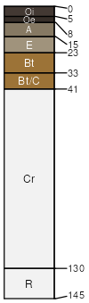
Wilkes sandy loam, clayey subsoil variant, 6 to 15 percent slopes
Wilkes variant
(100%)
Basic Upland Forest, Depth Restriction, Dry
Typic Hapludalfs
Well drained
Hydric: No
PAWS: 5 cm
hills / Summit
hills / Shoulder
hills / Backslope
SSA
Scale
Published
Export
ga067
1:16,000
1969
2025-09-02